


Washington D.C. is a city designed for grandeur, but its scale can be deceptive. Standing at the base of the U.S. Capitol and looking toward the Lincoln Memorial, the two miles of the National Mall seem like a short stroll—until you actually start walking. In 2026, navigating the nation’s capital has become more intuitive than ever, thanks to a world-class transit system and a booming micro-mobility network. Whether you are here for the cherry blossoms or the historic corridors of power, ditching the rental car is the smartest move you can make. This guide will show you how to navigate D.C. like a local using the clean, efficient Metro and the ubiquitous e-bike network.
Article summary
- Navigating the Capital with the Digital SmarTrip Card
- Mastering the Metro Lines for Major Landmarks
- Capital Bikeshare: The Best Way to Explore the National Mall
- E-Bike Benefits and Designated Biking Lanes in DC
- Avoiding the Rush Hour Commuter Surge
- Combining Metro and Biking for a Seamless Day Trip
- Is the D.C. Metro safe to use at night?
- Can I bring my bike on the Metro?
- How much does it cost to use Capital Bikeshare?
- Conclusion: The Secret to a Stress-Free Visit
Navigating the Capital with the Digital SmarTrip Card
The days of fumbling with paper tickets or waiting in long lines at kiosks are over. The heartbeat of D.C. transit is the SmarTrip card, a unified payment system that works seamlessly across the Metro, Metrobus, and even several regional bus systems like the DC Circulator. For the modern traveler, the most efficient way to handle fares is to go completely digital.
Before you even leave your hotel, you can add a digital SmarTrip card directly to your Apple Wallet or Google Pay. Simply download the SmarTrip app or add it through your phone’s wallet interface. This allows you to enter stations with a simple “Tap-and-Go” motion, even without waking your phone screen.
- Instant Top-ups: You can see your balance in real-time and add funds instantly using your saved credit card.
- One Card, All Rides: Use the same digital balance for the train and the bus, making transfers effortless.
- Eco-Friendly: Digital cards reduce plastic waste and eliminate the $2 fee for physical cards.
You can find more detailed instructions on setting up your mobile device on the official WMATA website.
Mastering the Metro Lines for Major Landmarks
The Washington Metro (often called “The Metrorail”) is famous for its brutalist architecture, vaulted ceilings, and remarkable cleanliness. With six color-coded lines, it connects the suburbs of Maryland and Virginia directly to the historic core of the city. To see the sights without exhausting your legs, you need to know which stations serve as the “gateways” to history.
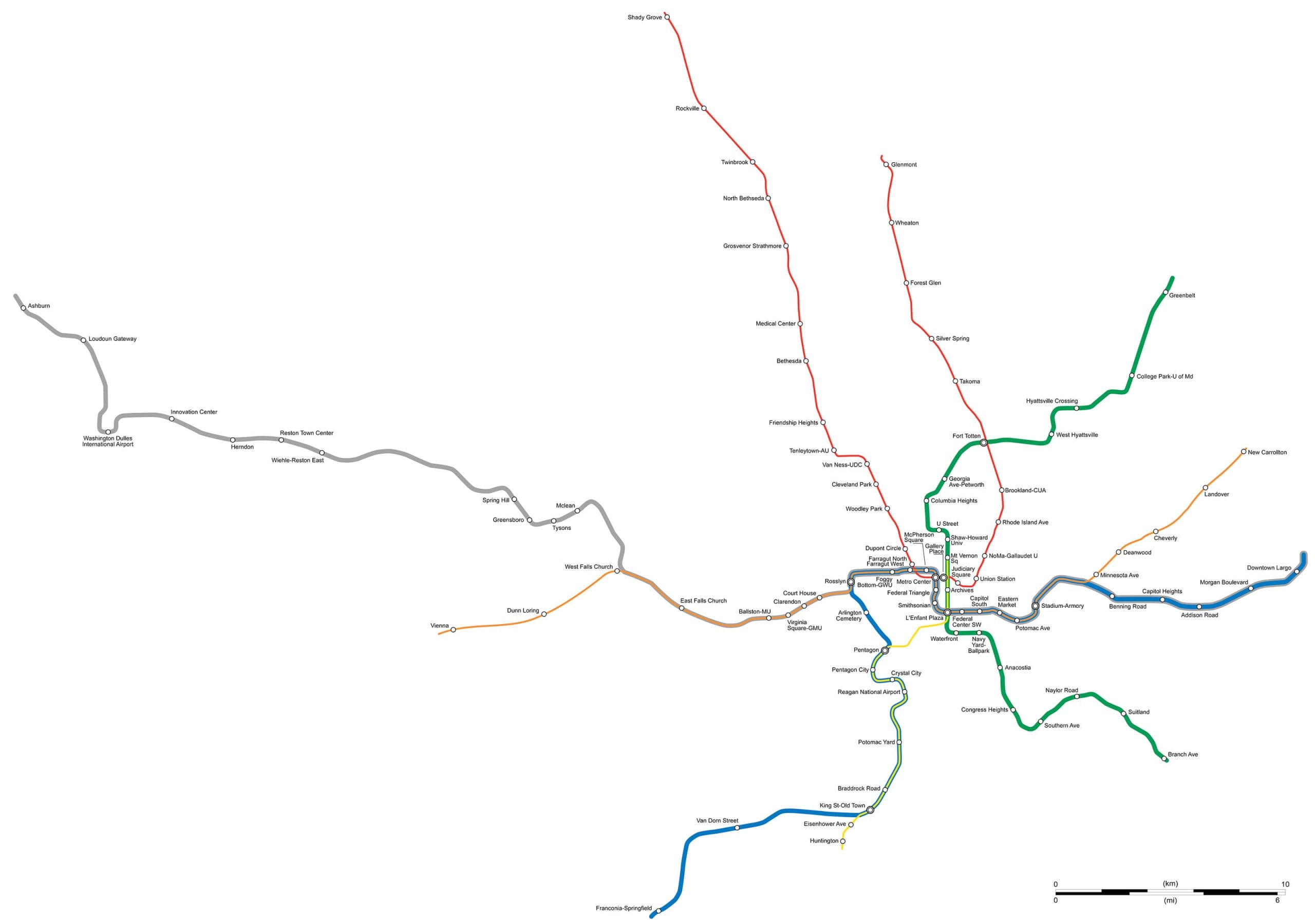
- The Blue, Orange, and Silver Lines: These are your primary tourist routes. Exit at Smithsonian to be dropped directly onto the National Mall, or Federal Triangle for easy access to the National Archives and the White House Visitor Center.
- The Red Line: This is the backbone of the city’s north-south transit. Use Union Station for the Capitol building or Woodley Park-Zoo for the National Zoo.
- The Yellow and Green Lines: Use L’Enfant Plaza for a short walk to the International Spy Museum or the Wharf.
For a real-time look at station locations and train arrivals, Google Maps remains the most reliable tool for live transit updates in the District.
Capital Bikeshare: The Best Way to Explore the National Mall
While the Metro is perfect for getting to the National Mall, the Capital Bikeshare system is the best way to move around it. The distance between the Washington Monument and the World War II Memorial, followed by the walk to the Lincoln Memorial, can easily add up to several miles. This is where the red bikes come in.
With over 600 stations across the metro area, you are never more than a few blocks from a ride. For tourists, the Single Trip or 24-Hour Pass options are ideal. Simply unlock a bike using the Lyft app or the Capital Bikeshare app, and you can dock it at any other station near your destination. This is particularly useful for the “monument loop,” where Metro stations are sparse. Docking a bike near the Martin Luther King, Jr. Memorial allows you to see the Tidal Basin and then hop back on a bike to head toward the museums.
E-Bike Benefits and Designated Biking Lanes in DC
In 2026, the fleet of electric bikes (e-bikes) in D.C. has expanded significantly. While traditional pedal bikes are great for the flat stretches of the National Mall, e-bikes are a game-changer when exploring the steeper inclines of Capitol Hill or the cobblestone streets of Georgetown.
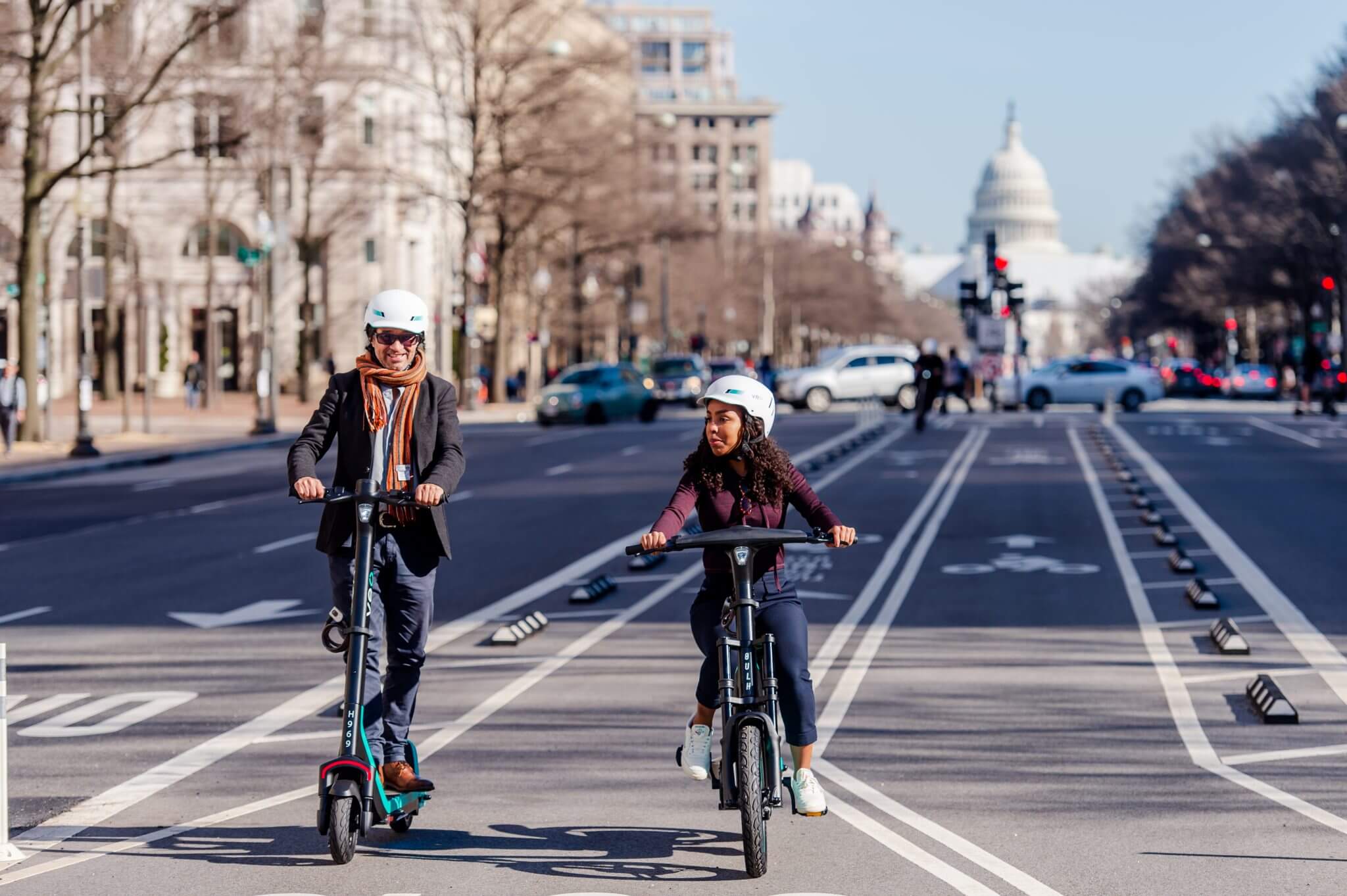
Safety is a priority in the District. Washington D.C. has invested heavily in “low-stress” biking networks, featuring protected bike lanes separated from car traffic by concrete barriers or parked cars. Major thoroughfares like Pennsylvania Avenue and 15th Street NW offer dedicated lanes that make cycling feel safe even for those who aren’t regular riders. The e-bikes provide a smooth “boost” that allows you to keep pace with traffic flow without breaking a sweat, ensuring you arrive at your dinner reservation in Adams Morgan looking fresh.
Avoiding the Rush Hour Commuter Surge
Timing is everything when navigating a major capital. Washington D.C. is a commuter city, and the Metro reflects that. To have a relaxed experience, try to travel during off-peak hours. Typically, the rush occurs between 7:00 AM – 9:00 AM and 4:00 PM – 6:00 PM on weekdays.
Dynamic Pricing: Metro fares in 2026 vary based on the time of day and distance traveled. Off-peak fares are significantly cheaper, often a flat rate for many trips, making it more budget-friendly to wait until 9:30 AM to start your museum tour. Additionally, trains are less crowded during mid-day, providing a much higher chance of snagging a seat to rest your feet between sightseeing stops.
Combining Metro and Biking for a Seamless Day Trip
The true “pro move” for a D.C. visitor is the hybrid itinerary. For example, you can take the Blue Line Metro across the Potomac River to Arlington National Cemetery. After paying your respects, walk across the street to a Bikeshare station and cycle back into the city via the Arlington Memorial Bridge.
Another great route is taking the Metro to Foggy Bottom, then grabbing a bike to ride through Rock Creek Park or over the Key Bridge into Georgetown. This “multi-modal” approach allows you to see the scenic waterfronts and skyline views that you would completely miss if you stayed underground or inside a ride-share vehicle.
Is the D.C. Metro safe to use at night?
Yes, the D.C. Metro is generally considered very safe. Stations are well-lit, monitored by the Metro Transit Police, and stay busy well into the evening. In 2026, increased frequency and improved lighting have made late-night travel common for both locals and tourists returning from the entertainment districts.
Can I bring my bike on the Metro?
Absolutely. Bikes are permitted on Metro trains at all times, including during rush hour. However, riders are encouraged to use the doors at either end of the railcar and avoid the middle doors to ensure there is plenty of space for passengers to board and exit.
How much does it cost to use Capital Bikeshare?
Prices vary, but a single 30-minute ride usually starts around $1 for classic bikes, with a small per-minute fee for e-bikes. For a full day of sightseeing, the Day Pass is the most cost-effective option, offering unlimited 30-minute rides on classic bikes for 24 hours. You can check the latest rates on the official Capital Bikeshare site.
Conclusion: The Secret to a Stress-Free Visit
The secret to enjoying Washington D.C. is realizing that the journey is just as important as the destination. By combining the efficiency of the Metro with the freedom of the Bikeshare network, you unlock the city in a way that car travelers never will. You’ll save money, skip the traffic, and see the architecture from the best possible vantage point.
Final Travel Tip: Download the DC Area Transit map on your phone for offline use. While cell service is great in the city, the deep underground Metro stations can sometimes be spotty, and having a map ready will ensure you never miss your transfer!